 Kalalau - Part 1
The Kalalau Trail along the NaPali Coast of Kauai, Hawaii stirs a number of emotions in people ranging from excitement to terror. As I researched the trail I think I felt those two extremes and all those in between. This stretch of coastline offers some of the most beautiful shoreline and secluded beaches in the world, but it also comes with inherent risks. However, my wife and I hiked the entire 22 miles in 3 days with no problems and we both think people are making too much fuss about the trail being so dangerous.

Backpacker magazine rates this trail among America's 10 most dangerous trails. When I found this out I felt fearful of the trail and almost dismissed the idea of hiking it. I'm glad I chose to continue my research.

It's important to understand why the trail is rated the way it is. Backpacker magazine (and others who echo this danger rating) base their evaluation on 3 main criteria: 1) the waters along this shoreline, particularly at Hanakapi'ai Beach, often have strong currents/rips especially during Northerly winter swells, 2) there are numerous stream crossings and if there are heavy rains in the mountains the streams quickly rise and run flash flood style for the following hours and 3) the trail is cut into the side of steep slopes both above valleys and directly above the ocean.

The dangers are: A) getting caught in a current and drowning, B) drowning/getting injured by being swept downstream trying to cross a swollen, fast moving stream or C) sliding/falling off the edge of the trail. After understanding the specifics of these scenarios, I realized that common sense and a little caution eliminates the first two and makes the third manageable: don't swim at all unless you're an experienced waterman (seriously apply humility here), don't cross swollen streams and when you get to the sketchy sections of trail simply proceed with caution (it is implied that you are properly equipped for these sections wearing aggressively treaded footwear, backpack packed low and close to your body and cinched up tight and a trekking pole on your downhill side adds stability). Also, if at all possible, hike the trail in dry conditions. Don't go in the middle of the rainy season because the trail will be very slick.

Let me just say that the trail was not terrifying and I hope to do it again! Regina was right there with me the whole way and after the worst sections she said "is that the part everyone is so scared of? That wasn't so bad." Let me add that I found it stated from several sources that there has never been a reported hiker fatality on this trail. See my write up below with pictures regarding the two "sketchy" sections of the trail. The following links are some resources/articles I used to research this trail.
http://en.wikipedia.org/wiki/Kalalau_Trailhttp://www.backpacker.com/october_08_americas_10_most_dangerous_hikes_kalalau_trail_kauai_hi/destinations/12626http://www.hawaii-guide.com/kauai/spot/the_kalalau_trailThe Kalalau trail is a very doable trail assuming a person is in decent shape and has experience hiking with a loaded pack. At the same time I definitely wouldn't describe it as easy. It covers 22 miles round-trip and, as shown in the chart below, gains and loses 300 to 600 feet numerous times. The first few miles to Hanakapi'ai Beach tend to be hot, humid and muddy and other sections beyond Hanakoa Valley (especially Red Hill with afternoon sun) can be dry and hot. Do not expect to maintain a 2 to 3 mph pace over this trail the way you might on other trails. 1 to 1.5 is alot more realistic which means you'd better plan on a 10 hour day going one way with a pack. (We hiked out with a 1 hr lunch break in 9 hours total).

Plenty of folks seem to focus on the "scary" parts of the trail and neglect the rest of the trail. The trail as a whole is really awesome. Totally breathtaking and so exciting to hike. It takes you in and out of valleys, past ancient Hawaiian sites and along the shoreline with breathtaking views.


There are two primary sections of the trail that most people get really concerned about. No. 1 is shortly after Hanakoa Valley around mile 7. This is a downhill switchback section which ends with the "balcony" which is a narrow section directly above the ocean. This section accounts for maybe 200 yds of trail. Some describe this section as sea cliffs. I would call them slopes, not cliffs. Describing them as "cliffs" makes them sound much more drastic that they are. Below are pictures of this section.

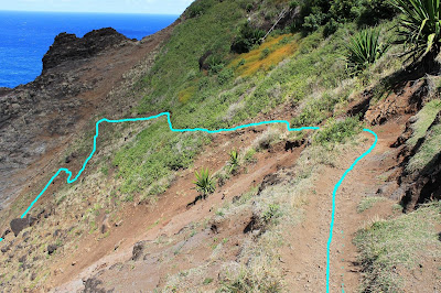
Above is a view of the switchback section as seen looking downhill. The image below is the same view with the trail hi-lighted. The switchback section is covered in loose gravel but it was not hard to maintain our footing. There was never a time that I struggled to keep from sliding. Keep in mind that the trail was DRY when we did this in October. After hiking it I realized it would be a completely different story if it was wet and rainy. The trail would be much more dangerous in wet conditions.

Above and below are the view looking downhill on the section that the switchbacks lead down to. On the far left is the "balcony." The footing on the balcony is actually better than the footing on the switchbacks. It appeared that this section had been maintained and built back up recently. I considered it to be in good condition. It was wide enough that we even passed a couple of people going the other way with no problem. The image below makes the balcony look narrower than it is because the trail curves around the rock and out of sight.

Below is the view standing on the balcony looking down. See what I mean? Slopes, not cliffs. In some of the discussions I've read, folks make it sound like you're walking along a vertical edge that you could just fall off of directly into the ocean. This is not the case. They are indeed slopes and as long as you're paying attention and walking carefully there's no reason for you to slide.

The view below is standing on the balcony looking back at a hiker coming down the switchbacks.

Reference the following blog for another write on this section:
http://great-hikes.com/blog/kalalau-trail-condition/Allow me to add the fact that we encountered folks hiking in all kinds of footwear: hiking boots/shoes, tennis shoes, slippers, and barefoot. One guy had duck tape on his feet with slippers. For some reason, pictures of this section make the trail look scary and much more dangerous than it is. If you just take your time and walk carefully you'll be fine.
Although most people give lots of attention to the balcony section, there is one eroded spot that was more of a concern to me. It lies just after mile 8. You come out of a little valley with a stream, round a point above the ocean and when you curve back inland there is a loose section with no vegetation. The section is only about 6 or 8 yards long. The soil is very loose and the trail is only about 6 to 8 inches wide. This section really needs some maintenance. See the pictures below.

Below is the view looking down from the trail at this section. Place your footing carefully and use a trekking pole on your downhill side and you'll cross this section with no problems.

Stay tuned for Part 2 of our Kalalau adventure.
 The trail is 12 miles round trip. The first 3 miles are easy going with a steady uphill but after the 3 mile mark it turns into a narrow jungle trail that slows to about a 1 mph pace at best. It took us almost 10 hours to complete the trail.


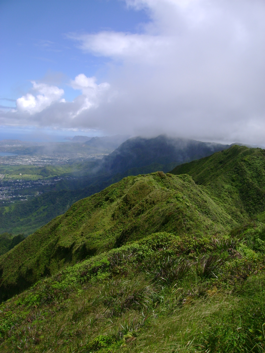


 Plenty of folks seem to focus on the "scary" parts of the trail and neglect the rest of the trail. The trail as a whole is really awesome. Totally breathtaking and so exciting to hike. It takes you in and out of valleys, past ancient Hawaiian sites and along the shoreline with breathtaking views.


 Above is a view of the switchback section as seen looking downhill. The image below is the same view with the trail hi-lighted. The switchback section is covered in loose gravel but it was not hard to maintain our footing. There was never a time that I struggled to keep from sliding. Keep in mind that the trail was DRY when we did this in October. After hiking it I realized it would be a completely different story if it was wet and rainy. The trail would be much more dangerous in wet conditions.
 Above and below are the view looking downhill on the section that the switchbacks lead down to. On the far left is the "balcony." The footing on the balcony is actually better than the footing on the switchbacks. It appeared that this section had been maintained and built back up recently. I considered it to be in good condition. It was wide enough that we even passed a couple of people going the other way with no problem. The image below makes the balcony look narrower than it is because the trail curves around the rock and out of sight.


 Below is the view looking down from the trail at this section. Place your footing carefully and use a trekking pole on your downhill side and you'll cross this section with no problems.